The Automatic Identification System (AIS) is a revolutionary maritime VHF data system that allows vessels and shore stations to continuously and automatically exchange identity, position, course, and speed data. Originally developed as a collision avoidance tool to enable commercial vessels to clearly “see” each other in all conditions, AIS significantly improves a helmsman’s situational awareness beyond the capabilities of traditional radar and visual look-out. Mandated by the International Maritime Organization (IMO) under the Safety of Life at Sea (SOLAS) convention, AIS provides mariners and shore authorities with a continuously updated, shared picture of marine traffic, making it a critical asset for navigation safety, Vessel Traffic Services (VTS), and search and rescue operations.
1. Introduction and Background
Before the advent of AIS, mariners relied almost entirely on radar and visual observation to monitor other vessels and prevent collisions. While radar remains essential, it is susceptible to being blocked by landmasses or degraded by heavy sea, rain, and snow clutter. AIS was developed to overcome these limitations by continuously transmitting a vessel’s precise identity, position, speed, and course to all other AIS-equipped vessels within range.
Because of its profound safety benefits, the IMO mandated the carriage of AIS Class A transponders internationally in 2002. This mandate applied to all vessels over 300 gross tonnes or those carrying more than 12 passengers. Over time, the use of AIS expanded beyond commercial shipping to include smaller fishing and leisure vessels through the introduction of Class B transponders, seamlessly integrating a wide variety of maritime traffic into a single, cohesive network.
2. Technical Architecture and Operation
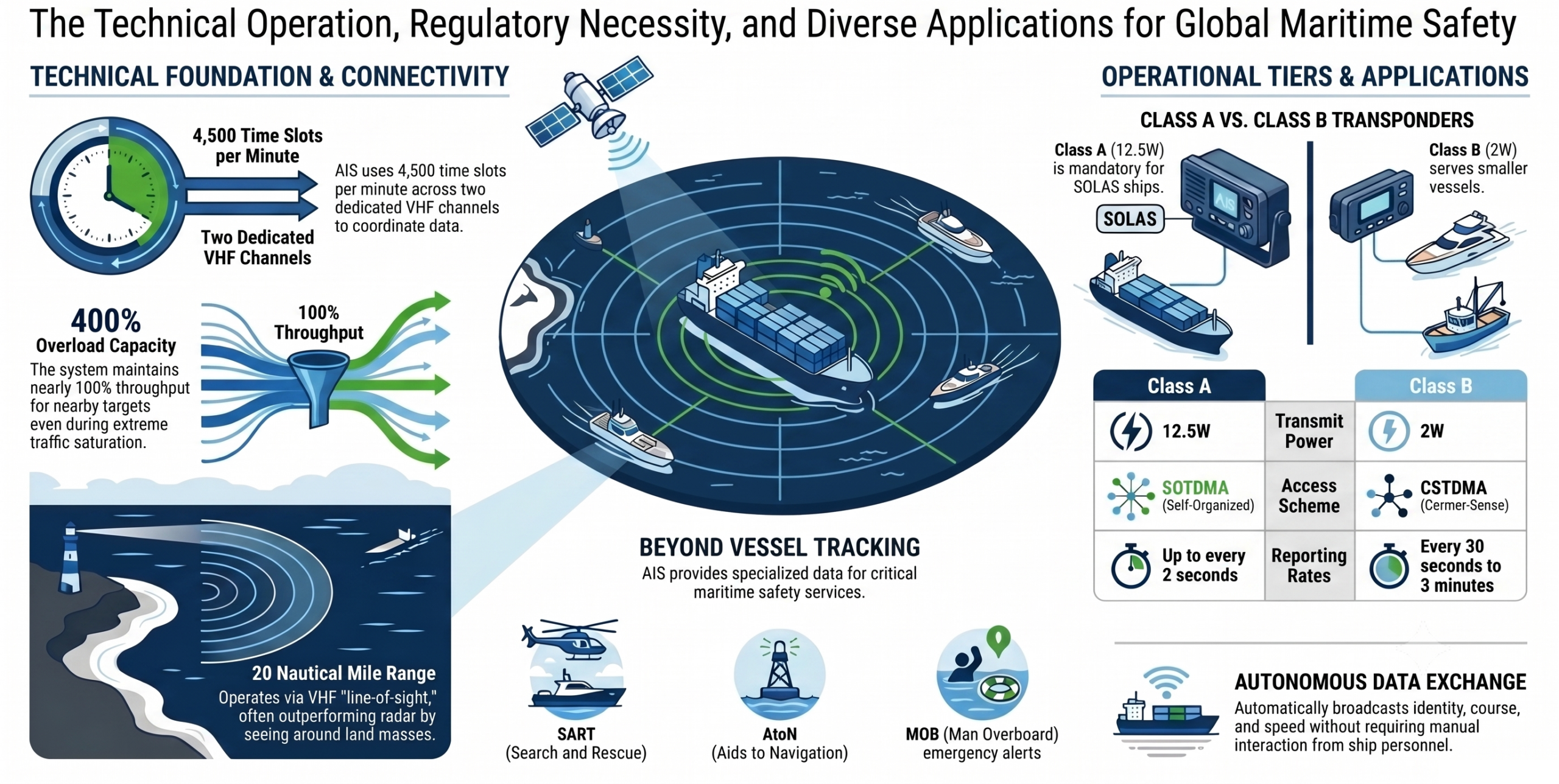
AIS operates autonomously and continuously using two dedicated maritime VHF channels: AIS 1 (161.975 MHz) and AIS 2 (162.025 MHz). By operating on these dedicated channels, AIS keeps its data exchanges completely separate from regular voice traffic. Transmissions are made using 9.6 kb GMSK FM modulation.
To prevent vessels from transmitting over one another and causing data interference, the system utilizes a technology called Time Division Multiple Access (TDMA). The VHF Data Link provides a total of 4,500 time slots per minute across the two channels (2,250 slots per channel every 60 seconds).
Key features of this architecture include:
- GNSS Synchronization: All AIS receivers are perfectly time-referenced using a Global Navigation Satellite System (GNSS), such as GPS, to ensure time slots do not overlap.
- Contention Resolution: The system automatically resolves scheduling conflicts and prioritizes targets that are closer to one another, preventing complete system failure even if overloaded by 400 to 500%.
- Coverage Range: Operating on VHF wavelengths, the range depends heavily on antenna height, but typically extends to a nominal 20 nautical miles at sea. Unlike radar, these wavelengths allow AIS signals to “see” around bends and behind islands.
3. Classes of AIS Transponders
To accommodate different types of vessels and regulatory frameworks, shipborne AIS transponders are broadly categorized into two main classes:
- Class A (SOLAS Compliant): Required on commercial vessels, Class A transponders broadcast at a higher power of 12.5 Watts and have a typical reception range of 20-25 nautical miles. They use Self-Organised TDMA (SOTDMA) to claim and reserve priority time slots on the network. Depending on the vessel’s speed and maneuvering status, Class A units update their dynamic position data very frequently—up to every 2 seconds for high-speed, turning vessels.
- Class B: Designed for non-SOLAS vessels like pleasure craft and smaller fishing boats, Class B transponders transmit at a lower power of 2 Watts, achieving a typical range of 7-8 nautical miles. They primarily utilize Carrier Sense TDMA (CSTDMA), which “politely” listens for an empty time slot before transmitting, ensuring they do not interfere with Class A priority traffic.
Both classes transmit two distinct types of information: Dynamic Data (position, speed, heading), which is updated continuously, and Static/Voyage Data (vessel name, call sign, MMSI, dimensions), which is transmitted every 6 minutes.
4. Types of AIS Stations and Messages
Beyond shipborne transponders, the AIS ecosystem encompasses a wide variety of specialized stations and message types designed for traffic management and safety.
Fixed and Search & Rescue Stations:
- Base Stations: Managed by competent shore authorities, these coordinate the VHF Data Link, control network traffic, and provide coastal surveillance for VTS.
- AIS Aids to Navigation (AtoN): Installed on buoys or lighthouses to broadcast their location and operational status. They can even exist as “Virtual AtoNs,” where a signal is broadcast for a hazard that has no physical marker.
- AIS-SART, MOB-AIS, and EPIRB-AIS: These are critical Search and Rescue (SAR) devices. AIS-SARTs replace traditional radar SARTs for life rafts, providing greater range, while Man Overboard (MOB) devices indicate the exact position of an individual in the water.
5. Applications, Benefits, and Future Developments
The implementation of AIS provides extensive operational advantages and forms the foundation for future maritime technologies.
Benefits and Applications:
- Collision Avoidance: Navigation software and chart plotters use AIS data to calculate a vessel’s Closest Point of Approach (CPA) and Time to Closest Point of Approach (TCPA). If a target breaches the mariner’s safe threshold, the system triggers visual and audible alarms.
- Identification and Communication: AIS removes the anonymity of radar blobs. By providing the target’s Maritime Mobile Service Identity (MMSI) number, mariners can directly contact dangerous vessels via VHF Digital Selective Calling (DSC).
- Traffic Management: Ports and littoral states use AIS to monitor shipping routes, secure mandatory reporting zones, and manage vessel traffic efficiently through VTS.
Future Developments:
- Satellite AIS: By utilizing specific AIS messages (Message 27), low-earth orbiting satellites can detect Class A broadcasts, extending vessel tracking globally across entire Exclusive Economic Zones (EEZs) and remote oceans.
- VDES (VHF Data Exchange System): As part of the IMO’s e-Navigation strategy, VDES is being developed to handle higher volumes of data communication for electronic chart updates, secure transmissions, and marine safety information.
Summary
The Automatic Identification System is arguably the most significant advancement in maritime navigation safety since the invention of radar. By leveraging GNSS synchronization, an autonomous TDMA architecture, and dedicated VHF channels, AIS guarantees that mariners and shore authorities share a continuously updated, highly accurate traffic image. Distinguishing between Class A and Class B transponders ensures that the network accommodates both massive commercial liners and small leisure crafts without compromising the safety-critical data link. As technologies like Satellite AIS and VDES continue to evolve, AIS will remain the cornerstone of global maritime situational awareness, collision avoidance, and modern e-Navigation.