GNSS Technology: Precision Positioning, Navigation, and Timing
Global Navigation Satellite Systems (GNSS) are fundamental to modern infrastructure, providing critical positioning, navigation, and timing (PNT) services to billions of devices worldwide. While the United States’ Global Positioning System (GPS) is the most widely recognized, the GNSS landscape now includes multiple major constellations such as GLONASS, Galileo, and BeiDou. Beyond simple location tracking, GNSS is the invisible backbone of global timing, synchronizing communication networks, power grids, and financial systems. With the continuous modernization of satellite segments and the development of multi-constellation receivers, GNSS technology delivers unprecedented accuracy and resilience. This white paper explores the history, architecture, underlying principles, global constellations, and critical applications of GNSS technology.
1. Introduction to GNSS and GPS
The Global Positioning System (GPS) was the pioneering system that laid the groundwork for modern GNSS. Initiated by the U.S. Department of Defense in 1973, GPS was designed to overcome the limitations of previous ground-based navigation systems. The prototype spacecraft was launched in 1978, and the system achieved full operational capability with a 24-satellite constellation in 1993.
Originally intended as a military asset to ensure precise navigation and nuclear deterrence, GPS was made freely available for civilian use in the 1980s following the tragic downing of Korean Air Lines Flight 007. Initially, civilian signals were intentionally degraded through a feature called Selective Availability (SA). However, recognizing the immense commercial and civilian value of accurate positioning, the U.S. government disabled SA in 2000, immediately improving civilian accuracy from roughly 100 meters to about 5 meters. Today, GPS is considered a dual-use technology, serving as a shared national and global resource
2. System Architecture and Structure
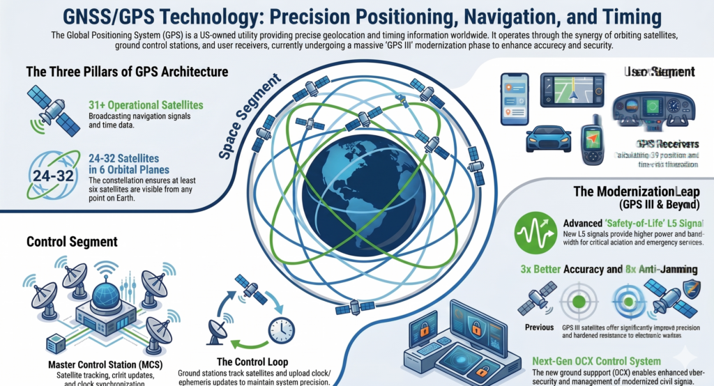
GNSS architecture, using GPS as the standard model, is divided into three primary segments: the space segment, the control segment, and the user segment.
- Space Segment: The GPS space segment consists of a constellation of 24 to 32 satellites operating in Medium Earth Orbit (MEO) at an altitude of approximately 20,200 km. These satellites are arranged in six orbital planes, ensuring that at least six satellites are always within the line of sight from almost anywhere on Earth. Each satellite orbits the Earth twice every sidereal day.
- Control Segment: This segment is responsible for maintaining the health and accuracy of the constellation. It includes a master control station, ground antennas, and a network of monitor stations worldwide. The control segment tracks the satellites, synchronizes their onboard atomic clocks, and uploads precise orbital models (ephemeris data) to keep the system performing within specifications.
- User Segment: The user segment consists of the receivers that process satellite signals to determine location and time. This encompasses hundreds of thousands of military users utilizing the secure Precise Positioning Service and tens of millions of civilian users relying on the Standard Positioning Service.
3. Signals, Frequencies, and Navigation Principles
GNSS operates on the fundamental principle of measuring the time of flight of radio signals traveling at the speed of light from satellites to receivers. Each satellite continually broadcasts a carrier wave modulated with a pseudorandom code and a navigation message containing the exact time of transmission and the satellite’s position.
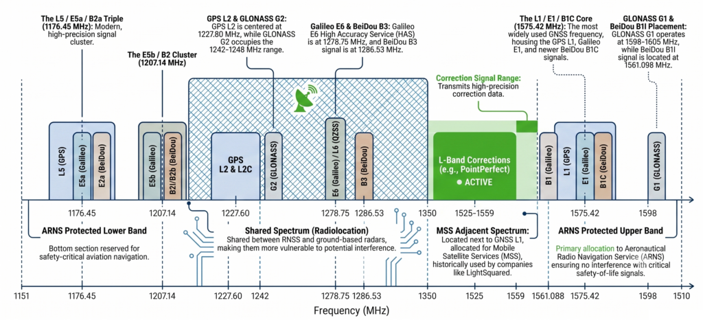
- Signal Frequencies: GNSS utilizes L-band signals. GPS primarily broadcasts on L1 (1575.42 MHz) and L2 (1227.60 MHz), with newer satellites supporting a third civilian signal, L5 (1176.45 MHz), which is highly beneficial for aviation and safety-of-life applications. Europe’s Galileo system operates on equivalent compatible frequencies, including E1 (1575.42 MHz), E5 (1191.795 MHz), and E6 (1278.75 MHz).
- Navigation Equations: To determine a three-dimensional position (latitude, longitude, altitude) and resolve the time offset between the receiver’s less accurate clock and the satellites’ highly precise atomic clocks, a receiver must acquire signals from a minimum of four satellites. The receiver aligns its generated code with the received code to determine the time of arrival, computing “pseudoranges” that are then solved via numerical least-squares or closed-form algebraic methods to pinpoint the user’s exact location.
4. The Major Global Constellations
While GPS remains the most prominent, true global coverage and optimal reliability are now achieved through the integration of four major GNSS constellations:
- GPS (United States): The foundational system, currently undergoing modernization to GPS III and IIIF satellites, which feature advanced atomic clocks and more powerful, interoperable signals.
- GLONASS (Russia): Developed concurrently with GPS, GLONASS achieved full global coverage in 2011 and provides an excellent complementary signal to GPS, specifically improving fixes in higher latitudes.
- Galileo (European Union): The European civilian-controlled system, fully deployed by 2020. Galileo offers highly advanced features such as the Open Service Navigation Message Authentication (OSNMA), a High Accuracy Service (HAS), and a Return Link Service for Search and Rescue (SAR) operations.
- BeiDou (China): China’s system, which completed its global deployment in 2020, uniquely utilizes satellites in medium-circle, inclined geosynchronous, and geostationary orbits.
Multi-constellation receivers combine these systems to deliver faster position fixes, better accuracy, and higher availability, ensuring reliable PNT services globally.
5. Applications and Vulnerabilities
GNSS applications are vastly diverse, categorized broadly into civilian, military, and critical infrastructure uses.
- Navigation and Tracking: GNSS is utilized in automated vehicles, fleet tracking, amateur radio, geodesy, and disaster relief. With accuracy enhancements like Real-Time Kinematic (RTK), Precise Point Positioning (PPP), and Satellite-Based Augmentation Systems (SBAS), accuracy can be improved from standard meters down to the sub-meter or centimeter level, enabling precise agriculture and rail operations.
- Timing Infrastructure: Precise time is as valuable as position in many infrastructure applications. GNSS disciplined oscillators provide highly accurate timestamping required to synchronize cellular networks, facilitate financial transactions, and manage power grid hand-offs.
- Vulnerabilities and Interference: Because GNSS signals are incredibly weak by the time they reach the Earth’s surface, they are vulnerable to both natural and artificial interference. Threats like deliberate jamming and spoofing pose significant risks to navigation and military operations. Consequently, robust, well-sited active GNSS antennas with low-noise amplification, stable phase centers, and multipath rejection are essential to acquire these weak signals reliably and reject interference.
Summary
GNSS technology is a remarkable synthesis of space engineering, advanced mathematics, and relativity, seamlessly woven into the fabric of modern daily life. What began as a strategic military tool has evolved into a global utility that underpins far more than simple navigation. As the United States modernizes GPS with Block III satellites, and Europe advances its Galileo constellation, the integration of multi-band, multi-constellation signals guarantees higher accuracy and formidable resilience. However, this reliance on space-based PNT demands continued innovation in receiver and antenna technology to combat vulnerabilities like spoofing and signal jamming. Moving forward, robust GNSS infrastructure will remain absolutely essential for the continued synchronization and navigation of our increasingly automated and connected world.