Navigating the Waves – Modern Maritime Communication Technologies and the GMDSS Framework
Maritime communication relies on a highly coordinated, layered mix of radio bands and satellite systems to keep vessels safely connected across coastal, offshore, and deep-ocean regions. At the heart of this infrastructure is the Global Maritime Distress and Safety System (GMDSS), an internationally mandated framework under the Safety of Life at Sea (SOLAS) Convention that ensures rapid, automated distress alerting and search and rescue (SAR) coordination. This white paper explores the core terrestrial radiocommunication technologies (VHF, MF, and HF), the vital role of Satellite Communications (SATCOM), the architectural framework of the GMDSS, and emerging maritime technologies such as VDES, NAVDAT, AIS, and LRIT. As the maritime industry moves toward digitalization and broadband connectivity, these complementary layers provide a robust safety net from harbor to open ocean.
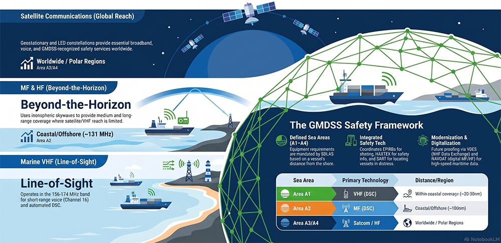
1. Terrestrial Communication Technologies
Terrestrial radio systems form the traditional backbone of maritime communications, divided into bands based on their frequency, propagation characteristics, and range.
- Very High Frequency (VHF): VHF operates in the 156-174 MHz marine band and provides short-range, line-of-sight communication. It is primarily used for bridge-to-bridge communications, port operations, and Vessel Traffic Services. The typical range is about 20 to 30 nautical miles, depending on antenna height and earth curvature. Channel 16 (156.8 MHz) is the international distress and calling channel for voice, while Channel 70 is dedicated exclusively to Digital Selective Calling (DSC) for automated distress and routine alerts.
- Medium Frequency (MF): MF radio waves (~1.6-4 MHz) travel by ground wave and are utilized for medium-range coastal and offshore coverage. A standard 250 W transmitter provides a range of approximately 100 to 125 nautical miles, though sky-wave propagation at night can extend this reach up to 1,000 nautical miles. The frequency 2182 kHz is the designated international distress and calling frequency for MF radiotelephony.
- High Frequency (HF): Operating between 3-30 MHz, HF relies on ionospheric sky-wave reflection to achieve beyond-the-horizon, ocean-going long-range and global communication. It supports voice, DSC, and narrow-band direct-printing (NBDP) / radiotelex in deep-ocean areas where VHF and satellite coverages are unavailable or limited.
2. Satellite Communications (SATCOM)
To achieve true global coverage, modern maritime operations rely heavily on mobile-satellite services. Recognized SATCOM systems are integral for deep-sea navigation and GMDSS compliance.
- Geostationary (GEO) and Low Earth Orbit (LEO) Systems: Inmarsat operates a GEO constellation providing services like Inmarsat-C and Fleet Safety, offering voice, data, and Maritime Safety Information (MSI) via the International SafetyNET service. Conversely, Iridium operates a LEO constellation of 66 satellites, providing global gap-free coverage, including the poles, through its SafetyCast and two-way voice/data services. Additionally, the BeiDou Message Service System (BDMSS) has been recognized for regional GMDSS use.
- Polar Region Challenges: Traditional GEO SATCOM faces severe limitations in the High North. Geostationary satellites become invisible at latitudes exceeding 80°N, and practical connectivity issues—such as signal dropout due to vessel motion (roll, pitch, yaw)—often arise beyond 70°N. Consequently, LEO networks like Iridium are critical for complete global coverage.
- Search and Rescue Satellites: The Cospas-Sarsat system operates on 406 MHz to detect Emergency Position-Indicating Radio Beacons (EPIRBs). The system is upgrading to the Medium Earth Orbit Search and Rescue (MEOSAR) constellation, which offers near-real-time global coverage and a Return-Link-Service (RLS) to confirm to survivors that their distress message was received.
3. The Global Maritime Distress and Safety System (GMDSS)
Fully implemented in 1999 and undergoing a major modernization effective January 1, 2024, the GMDSS is a SOLAS-mandated safety net that integrates terrestrial and satellite technologies. It shifts the focus from ship-to-ship alerting to a coordinated shore-based Rescue Coordination Centre (RCC) response.
The GMDSS requirements dictate equipment carriage based on four defined geographic Sea Areas:
- Sea Area A1: Within range of at least one VHF coast station with continuous DSC alerting (approx. 20-30 miles).
- Sea Area A2: Beyond A1, but within range of at least one MF coast station with continuous DSC alerting (approx. 100 miles).
- Sea Area A3: Beyond A1 and A2, but within the coverage of a recognized mobile satellite service (such as Inmarsat or Iridium) supported by the ship’s onboard earth station.
- Sea Area A4: All remaining sea areas (typically polar regions outside recognized SATCOM coverage) requiring HF radio capabilities.
Key GMDSS Components:
- Digital Selective Calling (DSC): An automated paging system on VHF, MF, and HF that uses digital codes and Maritime Mobile Service Identities (MMSIs) to establish contact and transmit distress alerts containing the ship’s identity and precise location.
- Maritime Safety Information (MSI): Broadcasts of navigational warnings, meteorological forecasts, and SAR info. In coastal waters, this is primarily delivered via NAVTEX (518 kHz), while deep-sea vessels receive it via satellite Enhanced Group Call (EGC) services like SafetyNET or SafetyCast.
4. Other Relevant and Emerging Technologies
Maritime communications are evolving beyond basic voice and text, driven by the need for broadband data and the “e-Navigation” concept.
- Automatic Identification System (AIS): Operates on VHF to automatically exchange ship identification, tracking, and navigational data, serving as a vital collision-avoidance complement to marine radar.
- Long-Range Identification and Tracking (LRIT): Uses SATCOM to globally track and identify ships up to 1,000 nautical miles from the coast for maritime domain awareness.
- Ship Security Alert System (SSAS): A covert, satellite-based alerting system used to silently notify shore authorities of terrorism or piracy threats.
- VDES and NAVDAT: The VHF Data Exchange System (VDES) is an emerging technology integrating VHF data, Application Specific Messages, and AIS (including satellite components) to support e-Navigation. NAVDAT (Navigational Data) is a digital MF/HF system currently in development intended to complement or eventually replace NAVTEX for high-speed MSI broadcasting.
- Broadband and Wireless: For offshore and operational use, technologies like WiMAX (sub-GHz), VSAT, and 4G/5G networks are being leveraged to meet high-bandwidth demands for modern vessel LANs and crew welfare.
Summary
Reliable maritime communication is constructed on complementary layers: VHF for short-range line-of-sight, MF/HF for beyond-the-horizon reach, and SATCOM for truly global broadband and tracking. Bound together by the regulatory and operational framework of the GMDSS, these technologies ensure that vessels remain visible and safe, no matter how remote their voyage. As the International Maritime Organization (IMO) continues its modernization efforts—evidenced by the 2024 SOLAS amendments and the integration of new satellite providers and digital systems like VDES and NAVDAT—the maritime industry is successfully transitioning from legacy analog systems to a highly integrated, digital e-Navigation ecosystem. Continuous innovation and adherence to stringent equipment standards remain essential to keeping mariners connected and secure across the world’s oceans.